by: City of Davis
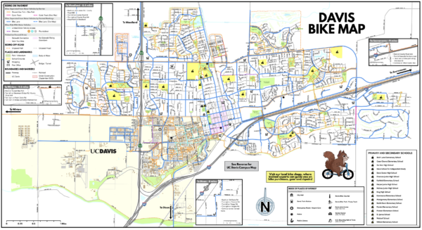
The City of Davis is pleased to announce the release of its newly updated Davis Bike Map, showcasing the City’s comprehensive network of bike lanes, shared-use paths, off-street trails and recommended routes—making it easier than ever to explore Davis with confidence.
The front side of the map has multiple routes, different colored paths and locations of key landmarks. The reverse side of the map includes helpful information for people of all ages and abilities who travel using active modes, such as:
- Rules of the road and key traffic laws
- Resources and contacts for local mobility and community organizations
- Guidance on electric devices, including relevant City regulations
- A Davis Bike Loop feature, a popular and family-friendly way to explore the community
Free copies of the updated Davis Active Transportation Map are now available at Davis City Hall, the Mary L. Stephens Davis Branch Library, the Davis Senior Center and many local bike shops.
The City encourages everyone to pick up a copy and discover Davis by foot, bike, scooter, wheelchair, skateboard or any other active mobility device.
To view the map online, go to: www.cityofdavis.org/bikes then open “Davis Bike Map” from the “Maps and Data” drop down menu.